Cape Hatteras Houses Collapse into Ocean: Is this the future of sea level rise?

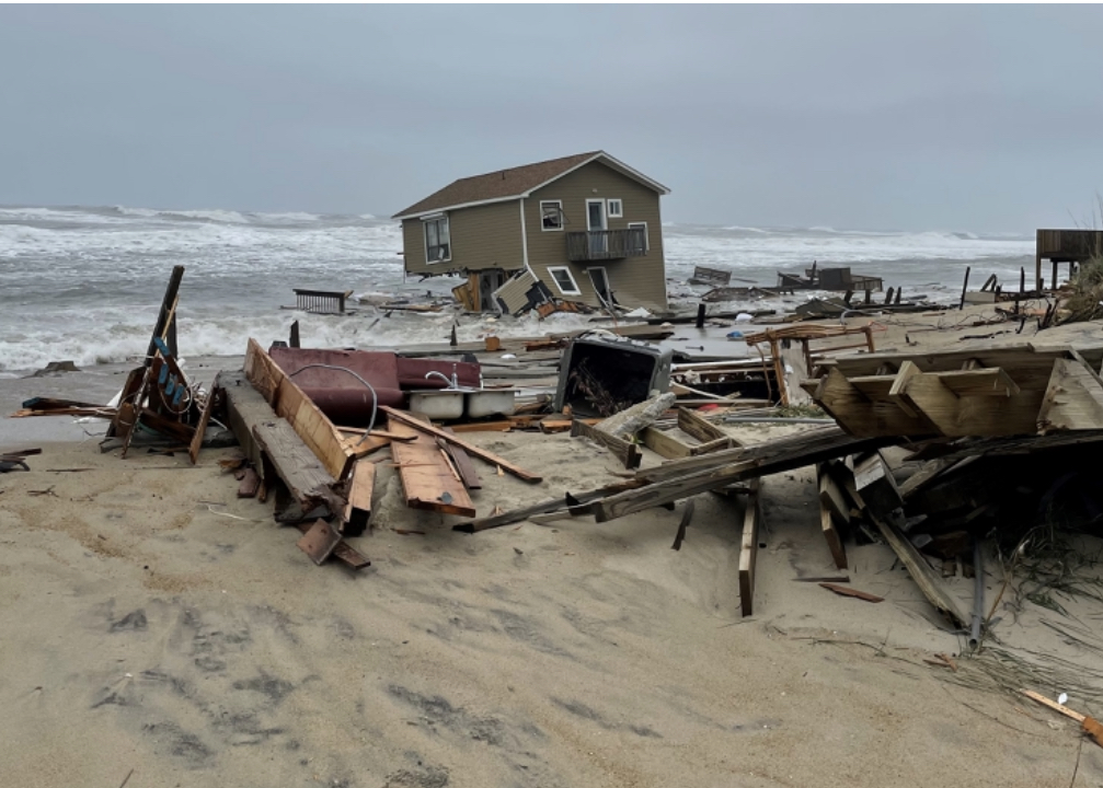
When it comes to sea level rise damaging beachfront real estate, Cape Hatteras National Seashore in the Outer Banks of North Carolina is the canary in the coal mine. The thin, sandy barrier island is infamous for losing houses to the sea whenever there’s a hurricane or strong tropical storm.

Now, before hurricane season even begins, houses in Rodanthe, south of Nag’s Head, are being swept out to sea. The National Park Service says three houses have been lost to the waves since February and another nine are currently at-risk of the same fate.

There are several factors contributing to the string of house collapses. A low pressure system swirling off the Outer Banks is sending powerful waves crashing onto shore. In addition, the barrier island has long experienced erosion due to regular wave action that gets worse whenever a hurricane or tropical storm hits or even passes close to the area.

Experts, however, have predicted that higher seas due to sea level rise would serve to intensify and speed up the erosion and house destruction, which only makes sense. Higher seas scour away sand more quickly and effectively. They also mean storm surges will travel further inland with more punch. In addition, the warming of the oceans and atmosphere due to climate change is super-charging hurricanes and tropical storms, which means they pack a stronger wallop.

Home loss on the Outer Banks is also due to the unique geology of barrier islands. In their natural state, the narrow sandy strands are meant to migrate inland as sea level rises. The Park Service is allowed to protect critical infrastructure, such as roads, but not houses. Even if the Park Service could take steps to shield the houses, such as building seawalls, nature would eventually break through the armor and sweep them out to sea.

It’s important to note here that scientists blame the loss of houses not only on natural forces but also the fact that humans never should have built the homes on shifting barrier island sand to begin with. Real estate owners and buyers need to carefully consider the consequences of owning real estate on barrier islands and beaches all along the US coast, especially now that sea level rise is in play. One thing’s for sure, houses toppling into the sea are going to become more common as the sea level rises and storms intensify in the decades to come.

(Photo Credit: National Park Service)

Freddie Mac Warns Sea Level Rise is Not Priced into Coastal Florida Real Estate Values

If you want to see where the real estate market is headed in light of climate change and sea level rise, watch lenders and insurers. Why? They have to be forward looking to protect their investment.

With that in mind, a research brief published this month by Freddie Mac, a governmental-sponsored company that backs mortgages, should sound a wake-up alarm to real estate buyers and owners in Coastal Florida (and across the country). In the piece, titled “Homebuyers in Coastal Florida are Not Factoring Sea Level Rise Risk into Home Prices”, Freddie Mac reported that prices are not being discounted for properties that are in sea level rise (SLR) exposed areas not within FEMA-designated floodplains. In fact, researchers found buyers of a primary residence, individual investors, and institutional investors were paying a 3.5% price premium for these homes.

Freddie Mac also reported that homes located in areas vulnerable to sea level rise experienced price discounts after hurricane flooding likely because buyers perceived a heightened flood risk rather than due to the risk of sea level rise itself.

“We conclude that homebuyers either lack awareness of SLR risk or consider it a long-term risk that will not be a concern during the time they own a home,” the researchers said.

Freddie Mac is concerned that the failure to consider the threat sea level rise poses to a property now could eventually lead to sea level rise-driven price drops later when (and if FEMA) updates its flood maps to reflect sea level rise flooding. The researchers say Florida’s housing market, with its large share of vulnerable properties built at very low elevation, could be significantly impacted.

This is yet another example of why owners and buyers of coastal property need to assess the risk posed by sea level rise flooding to make informed decisions and protect their financial futures.

Florida’s New Statewide Office of Resilience Gets Sea Level Rise Half Right

This week, Florida Gov. Ron DeSantis signed legislation to create a new Statewide Office of Resilience. The office is charged with creating an action plan to protect the state highway system from sea level rise flooding. It’s also responsible for creating a prioritize list of sites, such as medical centers, airports, utilities and emergency operation centers, that need to be hardened against rising seas.

The new law strengthens a 2021 law that required the state Department of Environmental Protection to develop a sea level rise resilience plan and a grant program to help cities and counties pay for infrastructure improvements.

While Florida officials should be applauded for taking the initiative and combatting the sea level rise that threatens coastal cities and towns, there’s a glaring omission. The law does nothing to reduce the burning of coal, oil and natural gas as well as agricultural sources of greenhouse gases that are driving global warming and sea level rise. This is kind of like working to put out a house fire without addressing the arsonist who’s flipping matches at it. This oversight will ultimately prove costly and disastrous for a low elevation state with coastal communities that are already flooding due to sea level rise and ever-stronger storm surges.

Florida’s half-way there on climate change and sea level rise. With billions of dollars worth of real estate under threat of inundation, let’s hope the state takes the next step and addresses what’s driving the problem.

With Hurricane Season Approaching, Now’s the Time to Purchase Flood Insurance

Hurricane season 2022 officially begins on June 1, and it’s expected to be a busy one.

With climate change and sea level rise intensifying tropical storm and hurricane rains and storm surge, now is the time for real estate owners in coastal communities and well inland to consider purchasing flood insurance — if they haven’t already. This is especially important because standard homeowner’s insurance policies do not cover flooding.

Property owners who plan to wait until a storm is aimed at their region to purchase flood insurance are making a big mistake. New policies under FEMA’s National Flood Insurance Program take 30 days to take effect.

Property owners who purchase properties using government-backed mortgages are required to purchase flood insurance policies. Many owners who purchased their homes using cash self-insure their properties. Some owners who are self-insured are under the mis-impression that because they’re located outside of designated flood zones that they shouldn’t be concerned about flooding. This can be a costly mistake. Estimates are that 25% of flood damage occurs in low-risk flood zones. An extreme example of this hazard is the fact that more than half of the homes that flooded in Houston, TX, during Hurricane Harvey were located outside designated flood zones.

Flood insurance policies cost on-average $700 a year, though FEMA has started to place a heavier premium burden on properties built in higher risk areas. The policies cover up to a quarter million dollars in damage. Buyers should also be aware that a seller’s flood insurance policy can be transferred to them at closing often at a significant savings.

Flood insurance is clearly worth purchasing. According to FEMA’s Flood Damage Cost Estimator, one inch of floodwater can cause up to $25,000 in damage and one-foot up to $72,000. As building materials and labor have become much more expensive in most regions of the country, these estimates are most likely on the conservative side.

Owners and buyers of real estate at risk of flooding can get more information about National Flood Insurance Program policies from the National Flood Insurance Program website.

New Hawaii Law Requires Sea Level Rise Threat Disclosure in Coastal Real Estate Transactions

Beginning this week, property owners selling coastal real estate in Hawaii are required by law to disclose the threat sea level rise flooding poses to a property. According to a State Department of Land and Natural Resources news release, real estate transactions involving properties located on or near the ocean must include the new disclosure. The new disclosure law is in addition to the National Flood Insurance Program’s requirement that sellers notify buyers that a property of interest is located near a flood-prone stream or area that may flood during heavy rainfall events.

According to an article posted on the Hawaii Life Real Estate Brokers website, the new disclosure law is based on modeling performed by researchers at the University of Hawaii. They studied coastal areas at risk from flooding or other damage due to sea level rises, annual high wave flooding, or coastal erosion.

Properties built between current sea level and 3.2 feet of elevation — the potential sea level-driven high water mark at the end of this century — are subject to the new disclosure law. Buyers, sellers and real estate agents can use the state’s interactive map to determine if they’re inside the disclosure zone.

Due to the hodge-podge of state-level sellers disclosure laws, buyers and sellers should always check to see what’s mandated in their area to avoid costly lawsuits and/or purchasing property that’s prone to flooding.

Commercial Real Estate Investors and Developers Need to Consider Sea Level Rise Flooding Risk

Sea level rise is impacting public lands and residential and commercial real estate. Just as residential real estate investors need to consider the threat of sea level rise flooding, commercial real estate buyers and owners need to keep on top of it, too.

A recent article (“What CRE Execs Need to Know About Sea Level Rise and the Law”) written by Anca Gagiuc and published by CommercialSearch.com — a multiple listing service for commercial real estate — takes a detailed look at what commercial real estate buyers and owners should consider when they’re deciding how to proceed in coastal communities. In the article, Gagiuc interviews Emily Lamond who works in the environmental department at the Cole Schotz law firm.

Lamond says that commercial developers are already responding to sea level rise by raising land elevation, buildings, roads and critical infrastructure. Renters, buyers and mortgage providers are also interested in buildings that can resists or withstand sea level rise flooding.

Other issues explored are who has liability if a property is flooded and damaged to the point that it is essentially totaled. Lamond says typically the owners are responsible for demolishing and removing damaged buildings. She recommends that owners review their insurance policies to see what’s covered in this situation and also prepare for the possibility of unexpected costs.

Lamond touches on several other points that commercial and residential real estate buyers and owners should consider when evaluating property located in coastal communities threatened by or currently experiencing sea level rise flooding. The entire interview is definitely worth a look.

Powerful New Tool Gives Real Estate Owners, Developers, Planners & Government Officials a Detailed View of the Threats Posed by Sea Level Rise

One of the greatest challenges for coastal real estate owners, developers, planners and government officials is acquiring a detailed understanding of the complicated challenges sea level rise flooding poses to their communities.

A new tool introduced today by the Southern Environmental Law Center (SELC), a non-profit and non-partisan organization dedicated to defending the environment, aims to deliver a clear view of the threats sea level rise poses to coastal communities in the Southeast through the use of an interactive mapping tool. “The project’s goal is to show citizens and decision-makers how the coast is changing,” the SELC said in a news release, “and how proposed infrastructure projects like highways, neighborhoods, and government or industrial facilities will fare as the water keeps rising and floods get worse.”

Visitors to The Changing Coast website will find an interactive map with overlays that enable them to visualize: 1. The flooding that will occur in their community as sea level rises; 2. Development projects that will be impacted by higher seas; 3. The locations of toxic Superfund sites that could contaminate neighborhoods and water supplies if they’re flooded by ocean water; 4. The locations of socially vulnerable populations who are most at-risk from sea level rise flooding and storm surges; 5. Wetland areas and floodplains that need to be protected from development to act as sea level rise floodwater buffer zones; and 6. Areas that are most at-risk from more powerful storm surges resulting global-warming-fueled stronger hurricanes and tropical storms.

Among the real-world examples of areas where the interactive mapping tool could assist real estate owners, government officials, planners and developers in coastal communities, the SELC offered the following:

  • “A proposed 9,000-acre housing development in Charleston could flood now with just a Category 1 hurricane. And rising seas could put parts of the development under water before the mortgages are paid off.”
  • “The roads leading to the proposed Mid-Currituck Bridge in North Carolina could be flooded on sunny days in the future if sea level climbs just two feet, rendering the span useless.”
  • “A 21-million-ton pile of toxic coal ash on the banks of the Mobile River in Alabama could likewise be threatened by a Category 2 hurricane, and that threat only increases as sea levels continue to rise. A breach could spread toxic ash into the river, through the Tensaw Delta, and into Mobile Bay.”

“The goal is to help guide decisions for the future, and to plan smart strategies to protect what exists now,” said Chris DeScherer, and SELC senior attorney.

The SELC’s interactive map is a valuable source of information that real estate owners, buyers and agents in the Southeast should use when considering property in coastal communities currently experiencing sea level rise flooding or at-risk of experiencing it in the near future. It would be wonderful if this powerful tool became available in other parts of the country.

Want to Fend Off Sea Level Rise Flooding? Start with Your Natural Gas Stove

A study released last week that concluded natural gas cooking stoves in the U.S. alone are leaking the equivalent of 500,000 cars-worth of greenhouse gases every year is a powerful reminder that real estate owners must play a role in combatting global warming and sea level rise flooding.

Researchers at Stanford University said in the study, published in the journal Environmental Science & Technology, that natural gas cooking stoves in over “40 million U.S. residences release methane — a potent greenhouse gas — through post-meter leaks and incomplete combustion.” They noted that three-quarters of the methane was released when the stoves were off. Around 80 percent of the methane leaked from loose couplings and fittings that connect gas pipes to stoves.

For years, the natural gas industry worked to convince the public that natural gas was a clean energy alternative. Using natural gas to produce energy does in fact release half as much carbon dioxide as burning coal to generate the same amount of energy. But scientists are increasingly concerned that the production and transportation of natural gas is leading to the release of dangerous amounts of methane — a more potent but shorter lived greenhouse gas than carbon dioxide — into the atmosphere.

A report published by Global Energy Monitor, a non-profit that monitors the fossil fuel industry, concluded that projects the oil and gas industry plan to fund to increase the use of natural gas globally would lead to the release of greenhouse gases in excess of all the coal fired plant put together. Ultimately, natural gas could keep us on track toward climate change catastrophe.

So what’s a homeowner to do? Climate groups are encouraging them to replace their natural gas powered stoves, hot water heaters and other appliances with electric appliances. For those who can’t afford to replace them, Rob Jackson, a professor of earth sciences at Stanford who was one of the stove study authors, told National Public Radio said they should use a wrench to tighten the connectors between pipes and stoves. The American Gas Association told NPR this work should only be performed by licensed professionals.

The point of this story is that people who own real estate in coastal communities that’s threatened by sea level rise flooding should certainly do everything they can to, such as raising seawalls and structures, to protect their property from rising waters, which is a symptom of climate change and global warming. But they also need to do everything they can to reduce the root cause of the problem, which is clearly any human activity that leads to the burning of fossil fuels and the release of greenhouse gases into the atmosphere.

If they have a gas stove, they need to replace it or make sure it’s properly maintained. Other steps they can take to help include ensuring that their property is weather-proofed and equipped with the most efficient appliances available today. Even switching off lights and electronics that aren’t being used can make a difference.

What will Coastal Cities Look Like if We Don’t Curtail Greenhouse Gas Emissions? Take a Look:

If a picture is worth a thousand words, then the collection of photos Climate Central — a nonprofit news organization — touched-up to show what sea level rise flooding will do to coastal cities around the world if we don’t cut back on greenhouse gas emissions should leave you downright speechless.

The environmental group recently published before and after photos of the sea level rise flooding 184 sites from Dhaka Bangladesh to Charleston, South Carolina and everywhere in between will experience at varying levels of global warming from the preferred target of 1.5 degrees centigrade all the way up to 4 degrees centigrade. The collection is published under the title “Picturing Our Future” and tagged “Climate and energy choices this decade will influence how high sea levels rise for hundreds of years. Which future will we choose?”

Researchers used new global elevation data from a study titled “Unprecedented threats to cities from multi-century sea level rise” published on the IOPScience website to generate the photos. The study itself states “a portion of human-caused carbon dioxide emissions will stay in the atmosphere for hundreds of years, raising temperatures and sea levels globally.” They go on to explain that globally, we’re falling short of what needs to be done to avoid the worst case sea level rise flooding scenario. “Most nations’ emissions-reduction policies and actions do not seem to reflect this long-term threat,” they wrote, ” as collectively they point toward widespread permanent inundation of many developed areas.”

It’s critically important to note here that sea level rise isn’t a future threat, it’s happening now in coastal cities across the U.S. and around the world. In the US, federal, state and local government entities are already investing billions of dollars in funds to raise seawalls, roads, water and sewer systems, and other critical infrastructure. And these efforts are seen as merely a tiny fraction of what will actually be needed to fend off floodwaters in the years and decades to come. Many real estate owners in coastal areas that are experiencing flooding are already having to pay out of pocket to raise seawalls and elevate their houses. In areas that can’t be saved, some states are offering buy-outs to property owners.

The bottom line is today and tomorrow we will be dealing with sea level rise flooding. The decisions we make today will have short-term and long-term implications. Educating yourself on sea level rise flooding has never been more important.

Moon Wobble will Increase Sea Level Rise Flooding in the 2030s

Sea level rise and sea level rise flooding have been gradually increasing for decades, but scientists are predicting a noticeable jump in the next decade. Why? A predictable wobble in the moon’s orbit will place Earth’s tide-driving companion closer to the planet from 2030 to 2040. A closer moon means higher high tides and lower low tides.

When you combine the moon’s stronger gravitational pull on the oceans with climate change-driven sea level rise, we can expect to see even more sea level rise flooding than we’re now witnessing in coastal communities. In fact, experts are predicting the moon wobble will result in sea level rise flooding conditions that were not expected until the end of this century. For example, scientists estimate San Francisco will experience five times more high-tide flood days in the next decade than it does now.

To arrive at their disturbing conclusion, NASA researchers reviewed data from tide gauges located in coastal communities in every state and territory but Alaska, which, due to its position on the globe, is not expected to face higher tides due to the moon wobble. The research was published in the journal Nature Climate Change.

Buyers and owners of real estate currently experiencing sea level rise flooding or located in communities that flood need to add the wobble into their long-term property ownership decisions. Flooding is already forcing the government and property owners to spend billions of dollars to fend off floodwaters and protect critical infrastructure. A sudden leap will only worsen property damage and result in higher outlays for maintenance, taxes and insurance.

%d bloggers like this: