Hurricane Ian Exposing Real Estate Prone to Sea Level Rise Flooding

As Hurricane Ian churns toward Florida today, it’s sending rain bands into the southern half of the peninsula. Driving in South Florida where I live, I saw several streets and intersections near the Intracoastal Waterway that don’t normally flood during heavy rainstorms filled with a foot or more of water. Real estate was also being impacted. While the rain is certainly contributing to the flooding, the real culprit is king tides — extra high tides due to the alignment of the sun and moon — combined with sea level rise.

Unfortunately, the storm is striking at the height of a week of higher than normal tides that peaks on Thursday. If today is any indication, the flooding is going to not only flood roads, it’s going to flood yards and homes in the days to come.

Each neighborhood I visited was flooding because of saltwater topping seawalls, emerging out of storm grates, or because pump systems couldn’t keep up. Sadly, I also saw some residents awestruck that their neighborhoods were flooding, even though some of them have been flooding for years. My best guess is that they purchased the properties without being aware of the flooding risk.

Another point to ponder is that many people who bought a property that itself isn’t flooding are discovering that owning real estate that you can’t reach because of sea level rise flooding is a major management issue and a pain in the neck. It’s also disconcerting because unless the flooding is prevented — through the use of elevated seawalls, elevated roads or pumps — sea level rise will eventually cause the flooding to swamp yards and homes.

What I witnessed today in my town is certainly occurring in many other coastal communities this week. It’s a powerful reminder that owners in coastal communities need to start considering sea level rise in their plans, and buyers need to perform due diligence to make sure that their property of interest, streets and neighborhood aren’t currently flooding or likely to flood in the future hurricane or no hurricane.

Video: King Tide Sea Level Rise Flooding Season Kicks Off Along the US Coastline

Aaaaaaand, here we go again. King tide sea level rise flooding season kicked off this week in the historic Marina District in Delray Beach, Florida. Every fall, the sun and moon align in a way that creates extra high tides over and over again.

Coastal communities all over the US are experiencing similar sunny day flooding that’s only getting worse due to sea level rise. Cities and towns are spending billions of dollars to hold back the water, which will ultimately be proven futile unless we cut back on burning the fossil fuels that are causing global warming.

This round of flooding, which peaks on Thursday, is bound to worsen the storm surge from Hurricane Ian. I really feel for the people who have to live like this. The salty water is murder on vehicles and property. Stay tuned.

Buyers Beware: Owners are Selling Properties Targeted for Sea Level Rise Flooding Buyouts

The Miami Herald ran two articles (both behind paywalls/titles listed below) on Sunday that discussed how the Florida Keys and Miami-Dade County are managing properties targeted for buyouts due to storm surge and sea level rise flooding. The Florida Keys is making some slow process in purchasing distressed properties, while Miami-Dade County has dropped the ball completely. In both locales, some owners dazzled by rapidly appreciating real estate prices have resorted to selling properties to buyers after applying to buyout programs, which, unfortunately, puts the new buyers, wittingly or unwittingly, at risk of flooding complications.

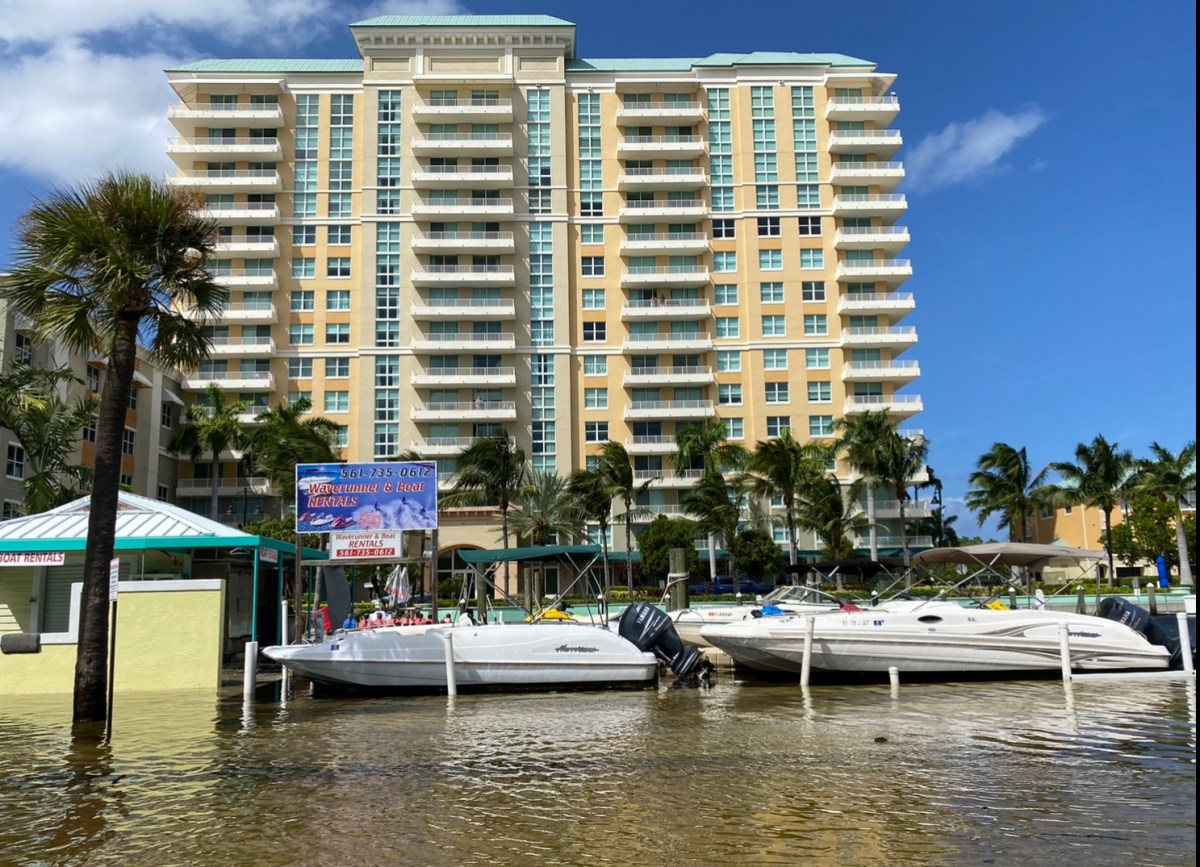
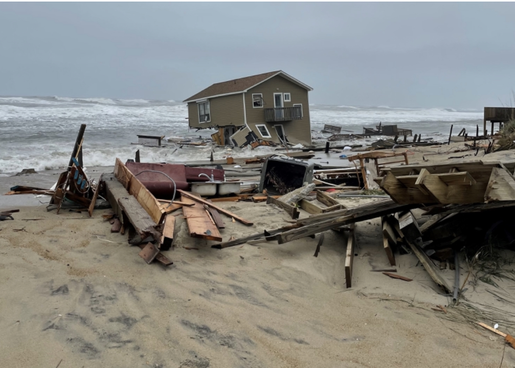
Thousands of US coastal properties have been purchased through government buyouts over the last decade, and the trend is accelerating as the sea level rises. Often the buyouts occur after hurricane storm surges (which are growing more powerful and damaging as sea level rises) flood neighborhoods. Buyouts are also becoming more common in areas that experience so-called rainy day or nuisance flooding due to much higher than normal tides.

National and state governments are eager to remove properties that require frequent, expensive repair or replacement from repeated flooding from the insurance rolls. They also want to avoid the expense of maintaining critical infrastructure — such as roads, sewer and water systems, and storm drains — in flood-prone areas.

After Hurricane Irma sent a powerful and devastating storm surge into some of the Florida Keys in 2017, Monroe County acquired federal funding to buyout damaged and flood-prone properties. The county received 80 applications from real estate owners and has purchased nine properties. County officials hope to buy another dozen soon.

According to the Miami Herald article, one massive roadblock that has prevented more purchases is rapid appreciation in the housing market over the last couple of years. In some cases, owners who had agreed to the buyout and demolition of their frequently-flooded properties decided instead to sell them for prices higher than they would have received under the buyout program. To remedy the situation, the county has received permission to offer more money for properties from the state agency that’s coordinated the buyout funds.

Miami-Dade County initiated a similar buyout program, but in three years the county hasn’t purchased a single one of ten properties that were targeted by buyouts. The lack of performance has led to the state administrative agency taking back the funds that were to be used for the purchases. Some of the buyout eligible property owners are angry that the county failed to complete the purchases as promised. In one instance, a developer has purchased a flood-prone property with the intent of constructing an 11-unit building on the lot. The developer was unable to tell the county what steps it would take to flood-proof the property but the county approved the project anyway.

Buyouts are controversial but necessary in areas where properties cannot be protected from storm surge and sea level rise flooding. Buyout opponents believe no matter how many times a property floods, insurers and governments are responsible for helping them to repair the damage and maintain roads and water and sewer service. Proponents, however, recognize when the battle is lost and they appreciated the government assistance when they’re ready to move on.

The current situation where some homes targeted for buyouts are actually purchased and demolished while others are being sold to buyers with or without them being aware of the property’s flood status needs to be addressed. The fact is each state has its own seller disclosure laws, so too often buyers are left in the dark about the level of threat posed by storm surge and sea level rise flooding. Until this unfair situation is resolved, buyers need to gather information from more than just sellers to ensure they’re not purchasing a property that was targeted for a buyout unless they’re prepared to accept the risk that their investment will literally end up underwater.

Editor’s Note: Here are the paywall protected article titles “Miami-Dade failed to buy flooded homes; Now high-risk sites open to more development” and “Buyouts take flood-prone Keys properties off the market. There are more sellers waiting”.

Credit Rating Service DBRS Morningstar Explores Threat Sea Level Rise Flooding Poses to Commercial Real Estate

DBRS Morningstar, a global credit ratings business, released a report this week titled “As Seas Rise, Coastal Commercial Properties Will Need to Batten Down the Hatches” that explores the threat sea level rise flooding poses to commercial real estate.

Analysts combined data from the National Oceanic and Atmospheric Administration (NOAA) — which estimates sea level rise in the next thirty years will exceed the total rise that occurred in the last 100 years — and flood risk data from First Street Foundation and Arup to identify the coastal communities most at risk of flooding. “The five metropolitan areas with the highest aggregated total projected structural damage costs across office, retail, and multi-unit residential buildings are the Miami (with an estimated $1.07 billion in structural damages), New York ($0.58 billion), Pittsburgh ($0.45 billion), Boston ($0.33 billion) and Houston ($0.29 billion) metropolitan areas,” according to the report. Inland Pittsburgh was included in the report because its proximity to three rivers that meet makes it “particularly susceptible to flooding”.

The report notes that in addition to a heightened risk of flooding from higher more powerful storm surges, more intense rainstorms, and nuisance flooding (tidal flooding that occurs when there are no storms around), owners of commercial real estate may find it difficult to pay for flooding-related repairs. That’s because the Federal Emergency Management Agency’s National Flood Insurance Program caps coverage at $500,000 for a commercial building and $500,000 for its contents. Owners have to turn to the private insurance market for additional coverage.

To combat sea level rise flooding, the report mentions options such as raising elevations at development sites, elevating mechanicals, and installing temporary/portable seawalls, but the authors also note that site-specific solutions aren’t enough. They have to be made in tandem with community efforts to protect critical infrastructure.

In addition to flood damage, insurance, and prevention efforts, the DBRS Morningstar report also mentions that credit rating agencies are beginning to consider the impact of sea level rise flooding as a factor in financial transactions. “Investors and underwriters no longer have the luxury of simply checking if a property is outside of FEMA’s 100-year flood zones and verifying there is some evidence of flood insurance,” the report says. “Because climate change is rapidly evolving, models based solely on historical data have become less accurate.”

The bottom line here is that commercial real estate owners can expect far more closer scrutiny of their individual properties and their exposure to sea level rise flooding when they’re seeking loans. This report is a must-read for anyone involved in commercial real estate located in coastal communities experiencing or at-risk of experiencing sea level rise flooding.

Sea Level Rise Will Impact 650,000 US Properties by 2050

A study released today by Climate Central, a climate change research group, concluded that 650,000 US coastal properties will be impacted by sea level rise flooding by 2050. To reach this conclusion, researchers analyzed state and county level tax reports in areas currently experiencing or at-risk of sea level rise flooding.

Among the key findings:

  1. More than 648,000 properties on 4.4 million acres are at risk of experiencing at least some measure of flooding.
  2. Over 48,000 properties may be entirely flooded.
  3. The low elevation states of Florida, Louisiana and Texas have the most at-risk properties.
  4. By 2100, over $100 billion worth of property will be at risk from rising seas.

The loss of properties threatens to create other problems for coastal communities and whole states. Properties that flood may become uninhabitable or lose value, which can harm the tax base that pays for schools, emergency services, critical infrastructure and numerous other services. Individual property owners, too, could also see their valuable real estate assets lose value, which can impact their wealth and retirement income.

To combat sea level rise flooding, governments in coastal communities are investing billions of dollars in property buyouts, pumping stations, the elevation of roads and other critical infrastructure, and the creation and improvement of sea walls and other flood-control barriers. In most cases, property owners are paying higher taxes to fund the projects. The loss of property value and tax revenues due to sea level rise flooding could create a spiral that makes funding these projects increasingly expensive, which will leave even more properties vulnerable to flooding.

Among the solutions Climate Central researchers recommend governments implement are encouraging development outside the sea level rise flooding risk zones, educating property owners about the risks rising seas pose to them, and, of course, reducing the burning of fossil fuels that are behind global warming and sea level rise.

Coastal Real Estate Owners Shouldn’t Take Comfort In New Study That Predicts Greenland Ice Melt Will Raise Sea Level By Nearly a Foot

This past week, major news outlets published articles about a study by geologists from the National Geological Survey of Denmark who said that even if greenhouse gas emissions ceased today, Greenland’s glaciers would melt enough to contribute nearly a foot to average global sea level. In addition, the study published in the journal “Nature Climate Change” said if global warming continues at the current pace, Greenland could add more than two feet to global sea level.

The researchers didn’t give a specific time frame for the sea level rise, but it’s assumed it would occur gradually over the next 100 to 150 years. Their main point is that the amount of greenhouse gases — carbon dioxide and methane currently in the atmosphere — has created a situation where Greenland will release a minimum of nearly a foot of glacial melt into the ocean no matter what we do.

Buyers and owners of real estate located in coastal communities who think a foot of sea level rise isn’t much shouldn’t find comfort in the report. First of all, it’s important to consider that the foot on-average of sea level rise that has accumulated so far due to global warming is already causing costly flooding in many coastal communities, and the number, severity and distribution of these flooding events is growing every year.

Next, it’s important to note that Greenland is only one small piece of the sea level rise puzzle. According to scientists, ice melt in Greenland has only contributed about 20 percent of total sea level rise so far. Ice melt in Antarctica has also caused about 20 percent of the total. While global warming heating up the oceans and causing them to expand has contributed about 50 percent of all sea level rise. The remainder is coming from glaciers melting in mountainous areas and other sources. If all of these sources driving sea level rise also have minimum amounts of sea level rise “baked in” due to the amount of greenhouse gases already accumulated in the atmosphere, the total amount of sea level rise in the years to come will be much higher than the Greenland’s nearly one foot.

Finally, real estate owners in coastal communities under threat of sea level rise flooding have to consider that sea level rise has been accelerating for years, and today’s estimates of total sea level rise will likely be adjusted upwards in the years to come. This is especially true because human society has not been reducing the amount of fossil fuels — coal, oil and natural gas — it has been burning, so overall global warming will continue to increase as will sea level rise.

The bottom line remains: Real estate buyers and owners in coastal communities need to continue to perform due diligence — drawing information from many sources — to calculate their exposure to sea level rise flooding.

New New York City Sea Level Rise & Storm Flooding Maps are Useful for Real Estate Owners & Buyers

After Hurricane Sandy slammed New York City ten years ago, the city began taking climate change and sea level rise seriously. The superstorm flooded low lying areas, inundated the subway system and road tunnels, and caused an estimated $19 billion in economic losses. The remnants of Hurricane Ida, which similarly flooded large swaths of New York, New Jersey, Connecticut and Pennsylvania last year, was a powerful reminder that more needs to be done.

To prevent loss of life and property, New York City has been busy producing a series of interactive flooding maps that tell real estate owners and renters whether or not they are in areas at high risk of flooding. Just last week, the city released interactive maps designed to inform residents of their flood risk under different scenarios. According to the city, the New York City Stormwater Flood Maps “show moderate stormwater flooding scenarios under current and future sea level rise conditions, as well as an extreme stormwater flooding scenario under future conditions.”

In addition to the maps, the city has a “Rainfall Ready NYC Action Plan” webpage that gives people the information they need to stay safe while infrastructure is built or upgraded to better cope with sea level rise flooding, more intense rainstorms, and more powerful tropical storms and hurricanes that are the results of climate change. The Action Plan includes information on how to prepare for storms, how monitor storm conditions, how to respond to storms, and how to recover from them.

The maps the city is producing are of great value to real estate owners and prospective buyers in the affected areas. Current owners can use them to not only to prepare their properties to withstand sea level rise and storms, but also to determine if the investment is worth it. Prospective buyers can use the maps to decide if they really want to get involved in real estate in an area that’s currently experiencing flooding or at risk of flooding in the future. This is critical information since properties that flood can lose value or appreciate at a slower rate than comparable properties in safe areas.

New York City’s proactive efforts to warn residents of the risks of flooding caused by climate change driven sea level rise and supercharged storms is admirable and should be replicated by cities and towns all along the US coastline. Used properly, they can help real estate owners and prospective buyers to make informed decisions that protect their financial futures.

Hot Housing Market Chills Flood-Prone-Housing Buyout Programs

One tool local officials have to combat sea level rise flooding that damages residential real estate is home buyouts. According to an Associated Press article, the Federal Emergency Management Agency (FEMA) has spent nearly $3.5 billion over the last 30 years to help communities purchase nearly 50,000 flood-prone properties. Typically buyouts are used so communities and insurers don’t have to bear the cost of repairing or rebuilding houses that repeatedly flood.

The rapid appreciation in real estate value over the past year, however, is posing a challenge to officials trying to buyout flood-prone homes. According to the Associated press report, owners who would usually accept the terms of a buyout are now, in many cases, turning them down with the hope that a buyer will pay even more than the buyout program offers. Another reason some owners are reluctant to sell is that they realize that all the real estate in their community has been appreciating so finding a replacement home in a location that doesn’t flood at an affordable price can be quite a challenge.

In response to the real estate appreciation challenge, FEMA is offering more money — up to $31,000 — to help homeowners find affordable replacement housing. Some states are also offering extra money to people who agree to be bought out.

Refusing a buyout is not without risk for homeowners. If their house floods while it’s up for sale, it will be difficult to find a buyer willing to purchase it. This is an especially serious issue for property owners in coastal communities during hurricane season.

This buyout situation should serve as a cautionary tale for buyers. To avoid unknowingly purchasing a flood-prone home that really should be bought-out to stop the repair and rebuilding cycle, they need to perform due diligence and determine whether the risk is worth it to them. Some coastal states — like Florida — don’t have strong sellers’ flood disclosure requirements, so they will have to conduct research on their own to independently confirm whether a property is flood prone. FEMA flood maps, local real estate agents, insurers, and mortgage providers are a great place to start.

Sea Level Rise Flooding Threatens More Than Your Real Estate

When people who own real estate in coastal communities consider the threat posed by sea level rise flooding, they often focus only on their own structures and land. That can be a costly mistake.

The fact is sea level rise flooding outside their property lines can impact their property value, financial future and quality of life. How? For example, nearby roads that flood can keep owners from reaching their property. Wastewater systems that are infiltrated by seawater can become ineffective or even inoperable, which can result in sinks and showers that don’t drain and toilets that don’t flush. And taxes can go up when cities and towns are forced to raise seawalls and other critical infrastructure.

A Civil Grand Jury in Humboldt County in Northern California is busy drafting an assessment that lists the many ways sea level rise will impact coastal communities there. In a report titled “The Sea Also Rises”, the Grand Jury warns that the county, which includes Arcata and Eureka, is at risk from flooding due to the double-whammy of sea level rise and natural land subsidence.

The list of problems the Grand Jury says will be created as seawater inundates more and more land includes the following:

  1. Communities around Humboldt Bay will experience more frequent flooding.
  2. Highway 101 and the only access road to King Salmon could be cut off by floodwater.
  3. The local energy system could be disrupted as flooding impacts a PG&E generating station, municipal water transmission lines, electrical transmission towers, and transmission poles.
  4. An interim spent nuclear fuel site could be damaged.
  5. Commercial properties, including three cargo and commercial docks, could be flooded.
  6. Environmentally contaminated sites in the Arcata and Fairhaven could be compromised.

The Grand Jury isn’t only forecasting future problems, it’s taking stock of problems that exist today. For example, the report says property values in the Fairhaven/Finntown area are already suffering because very high tides are causing septic systems and leaching fields to fail — which is a problem in many coastal areas experiencing sea level rise flooding.

In its draft summary, the Grand Jury is calling on all elected officials to make sea level rise flooding a priority. “The County of Humboldt; the cities of Arcata and Eureka; and the Humboldt Bay Harbor, Recreation, and Conservation District should formally state their immediate and continuous support for, and commitment to, SLR (sea level rise) mitigation and adaptation efforts,” it wrote.

Cities and towns all along the US coastline are taking stock of the threats posed to residential and commercial real estate, public lands, and critical infrastructure. A few years ago, an environmental consultant estimated that the mid-sized South Florida city I live in needs to spend $378 million to defend itself against sea level rise. With inflation, it’s likely the actual cost is higher now.

Owners and buyers of real estate in coastal communities need to know what’s at-risk from sea level rise flooding in their community, how much it will cost to eliminate and mitigate the flood waters, how much local taxpayers will be expected to contribute to the effort, and the soundness and life-expectancy of the projects being implemented and those under consideration. Not knowing this critical information could lead to an unexpected loss of property value and spike in taxes and other expenses.

Cape Hatteras Houses Collapse into Ocean: Is this the future of sea level rise?

When it comes to sea level rise damaging beachfront real estate, Cape Hatteras National Seashore in the Outer Banks of North Carolina is the canary in the coal mine. The thin, sandy barrier island is infamous for losing houses to the sea whenever there’s a hurricane or strong tropical storm.

Now, before hurricane season even begins, houses in Rodanthe, south of Nag’s Head, are being swept out to sea. The National Park Service says three houses have been lost to the waves since February and another nine are currently at-risk of the same fate.

There are several factors contributing to the string of house collapses. A low pressure system swirling off the Outer Banks is sending powerful waves crashing onto shore. In addition, the barrier island has long experienced erosion due to regular wave action that gets worse whenever a hurricane or tropical storm hits or even passes close to the area.

Experts, however, have predicted that higher seas due to sea level rise would serve to intensify and speed up the erosion and house destruction, which only makes sense. Higher seas scour away sand more quickly and effectively. They also mean storm surges will travel further inland with more punch. In addition, the warming of the oceans and atmosphere due to climate change is super-charging hurricanes and tropical storms, which means they pack a stronger wallop.

Home loss on the Outer Banks is also due to the unique geology of barrier islands. In their natural state, the narrow sandy strands are meant to migrate inland as sea level rises. The Park Service is allowed to protect critical infrastructure, such as roads, but not houses. Even if the Park Service could take steps to shield the houses, such as building seawalls, nature would eventually break through the armor and sweep them out to sea.

It’s important to note here that scientists blame the loss of houses not only on natural forces but also the fact that humans never should have built the homes on shifting barrier island sand to begin with. Real estate owners and buyers need to carefully consider the consequences of owning real estate on barrier islands and beaches all along the US coast, especially now that sea level rise is in play. One thing’s for sure, houses toppling into the sea are going to become more common as the sea level rises and storms intensify in the decades to come.

(Photo Credit: National Park Service)

%d bloggers like this: